 Our next excursion was a trip to the
 fair city of Antofagasta. Antofagasta lies approximately 130 miles to the southwest of Calama and took around three hours to get there.
We stayed at the Holiday Inn Express. I was sure we'd have those good cinnamon rolls for breakfast -- but no.
Here we were hanging out in the lobby enjoying CNN while enjoying a cold drink.
Antofagasta
(/antofa'γasta/) is a port city with a population around 280,000. I read that the city's name comes from either a Quechua or Aymara word for "town of the great saltpeter bed". The Chilean Coast Range (Cordillera de la Costa) is a mountain range that runs southward parallel with the Andean Mountains and provides the city with a border to the east with the Pacific Ocean to the west. Therefore, the city is long and narrow. Antofagasta was founded in 1868 by Bolivia to create a port that would provide an outlet for saltpeter (nitrate) exports and establish control over an area where Chileans had settled and were smuggling this material. Antofagasta's original name was "la Chimba," though the area was also known as Peñas Blancas (Spanish for "White Boulders"). It was part of the Bolivia until 1879, when it was occupied by Chilean troops. This event marked the beginning of the War of the Pacific.

Saturday morning we walked from our hotel to the nearby McDonald's and figured if we couldn't enjoy the Holiday Inn Express good cinnamon rolls, we'd instead enjoy a cup of coffee and an Egg McMuffin -- but no. We did get the coffee but our Egg McMuffin was on a hamburger bun and minus the egg?? By the way, we were the only customers there....
 This was our view from the room.
 We walked a lot this day. Cool building eh!
 Here we were in the Plaza Colon. Larry by one of the many statues.
 This is a replica of Big Ben in the Plaza Colon with a cool gothic styled Cathedral in the background and fountains that worked!! It was pretty.
On our way home we traveled north out of Antofagasta to visit La Portada -- a natural rock formation.
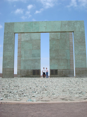
We then traveled to this monument just a little bit further up the road which marks the exact location of the Tropic of Capricorn. "At winter solstice, about December 22, the sun is overhead at noon at the Tropic of Capricorn; this marks the beginning of winter in the Northern Hemisphere. For several days before and after each solstice the sun appears to stand still in the sky, i.e., its noontime elevation does not seem to change from day to day." The monument was constructed such that at winter solstice, it is aligned to the solstice and at exactly the right time the sun shines through it.


These dead or dying cactus represent the line of the Tropic of Capricorn.
We saw this on our way back home. How did they do that?
I'll post Thanksgiving as soon as I get some pictures from other who took pictures. In the meantime, you may see our trip to Iquique which we took last weekend.


It appears that Chile is good for you, you two look healthy and happy. Hope to see ya on your next trip back to the States. Love ya The Goldricks
ReplyDelete